Super Typhoon Utor to enter East Sea tonight

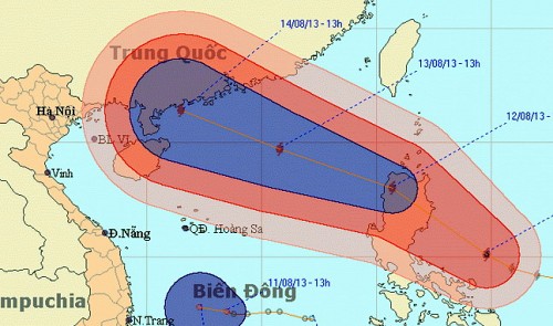
The expected path of Super Typhoon Utor National Hydro-meteorological Forecasting Center
At 7 am today, August 12, Utor was centered at 16.6 degrees latitude north, 120.9 degrees longitude east, in an area southeast of Luzon Island. Winds near the eye reached 134-166 kph, with gusts of 184- 220 kph.
The storm is moving west-northwest at a speed of about 20-25 kph and will sweep across the island before entering the northern area of the East Sea tonight.
At 7 am Tuesday, the typhoon will be located at 18.3 degrees latitude north, 115.3 degrees longitude east, about 370 km northeast of the Hoang Sa (Paracel) archipelago, with winds of 150-166 kph and gusts of up to 220 kph.
The typhoon will continue to move in the same direction at a speed of 15-20 kph, and at 7 am August 14, it will be centered in the northern area of China’ Hainan Island. Maximum winds near the storm’s eye will be up to 150-183 kph with gusts of 184- 220 kph.
Over the ensuing 24-48 hours, the typhoon will continue to move in the same direction at a slower speed of 10-15 kph.
The typhoon will cause rough seas and violent winds of 75-102 kph, which will gradually increase to 103-133 kph, in the northern area of the East Sea.
Le Thanh Hai, the director of the center, forecast that the typhoon may hit either Leishou Island, with a probability of 60-70 percent, or change its course to enter the Gulf of Tonkin, at a probability of 30-40 percent.
Depression moving slowly
Meanwhile, at 7 am today, the tropical depression was centered 330 km off the coast between Binh Dinh and Khanh Hoa provinces, packing winds of 39- 49 km and gusts of 50-74 kph.
The depression is moving at 5-10 kph and will likely change direction to east-northeast and weaken into a low pressure system.
At 7 am Tuesday, the system will be centered 240 km north of Song Tu Tay Island, part of the Truong Sa (Spratly) archipelago, with winds of less than 39 kph.
The depression is causing rough seas and winds of 49 kph in the middle and southern areas of the East Sea, including the Truong Sa Islands, and the waters between Binh Thuan and Ca Mau provinces will have rough seas and winds of 39-49 kph and gusts of 50-74 kph. Showers and thunderstorms, possibly together with whirlwinds, will occur in these areas as well.
Southern provinces and the Central Highlands region will see widespread heavy rain, together with thunderstorms in some areas.
The Central Steering Committee for Flood and Storm Prevention and the National Committee for Search and Rescue yesterday sent urgent messages to concerned agencies and local authorities from Quang Tri to Phu Yen Provinces, asking them to take measures to cope with the depression and the coming typhoon.
What the stars mean:
★ Poor ★ ★ Promising ★★★ Good ★★★★ Very good ★★★★★ Exceptional
Latest News
More News
- 14th National Party Congress wraps up with success (January 25, 2026 | 09:49)
- Congratulations from VFF Central Committee's int’l partners to 14th National Party Congress (January 25, 2026 | 09:46)
- List of newly-elected members of 14th Political Bureau announced (January 23, 2026 | 16:27)
- 14th Party Central Committee unanimously elects To Lam as General Secretary (January 23, 2026 | 16:22)
- List of members of 14th Party Central Committee announced (January 23, 2026 | 09:12)
- Highlights of fourth working day of 14th National Party Congress (January 23, 2026 | 09:06)
- Press provides timely, accurate coverage of 14th National Party Congress (January 22, 2026 | 09:49)
- Press release on second working day of 14th National Party Congress (January 22, 2026 | 09:19)
- Minister sets out key directions to promote intrinsic strength of Vietnamese culture (January 22, 2026 | 09:16)
- 14th National Party Congress: Renewed momentum for OVs to contribute to homeland (January 21, 2026 | 09:49)


 Mobile Version