New old map reinforces VN sovereignty over Hoang Sa
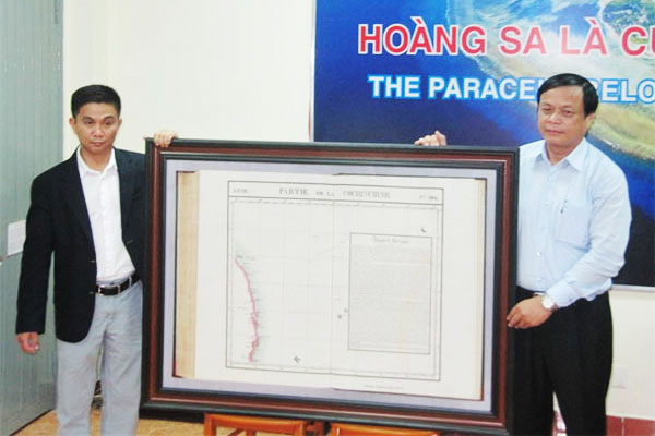 |
| Tran Thang (L) donates an 1827-printed map, Pattie De La Conchinchine, drawn by Belgium cartographer Phillippe Vandermaelen (1795-1869), to the Hoang Sa District’s People’s committee yesterday. |
An American-Vietnamese collector, Tran Thang, has donated to the Hoang Sa (Paracel) Island District the Pattie De La Conchinchine, an 1827 map printed in the six-volume World Atlas (Atlas universel) by Belgium cartographer Phillippe Vandermaelen (1795-1869).
The map, 1.2m wide and 0.85m high, is one of the most detailed maps indicating clearly Viet Nam’s sovereignty over the Hoang Sa (Paracels) Islands. The map is part of many that Thang has collected in Europe and the US since 2012.
The map, drawn by Philippe Vandermaelen, founder of the Belgium Royal Geographical Society, indicates that the central coast of Viet Nam stretched from the 12th parallel (in the area of what is Khanh Hoa Province now, to the 16th parallel (Quang Nam Province now).
The names used in the map are Bink-Knag, or Nhia Trang (Nha Trang City), and Champella (Cu Lao Cham or Cham Island).
The map also shows Hoang Sa (Paracels) Islands offshore between the 14th and 17th latitudes, and from the 109th to 113th longitudes.
The Hoang Sa (Paracels) Islands have been drawn in great detail accuracy, including Pattles, Duncan in the west; Tree and Lincoln, Bocher au dessas de l’eau in the east and Triton in the southwest near the 16th parallel, Investigateur in the south in the 14.5 parallel, and marking of a sea area 5m-10m deep to Quin Hone (Quy Nhon City in Binh Dinh Province now) in the 14th parallel.
“I’ve spent a lot of time collecting old maps that state or identify Viet Nam’s sovereignty over the Hoang Sa (Paracels) and Truong Sa (Spratly) Archipelagos. I wish to contribute more documents to the Hoang Sa Museum in Da Nang City,” Thang said.
“I have collected and donated 150 old maps, of which 80 Chinese maps indicate the frontier of Southern China is Hainan Island, and 50 indicate that the Paracels Archipelago belongs to Viet Nam,” Thang said.
Thang said the Pattie De La Conchinchine was a rare map printed early in the 19th century in great precision, using western written names of the islands in the Hoang Sa Archipelago.
He said Conchinchine, a name used to indicate the central region of Annam (a French protectorate encompassing the central region of Viet Nam), was part of Annam, and Hoang Sa (Paracels) was under sovereignty of Viet Nam at least from 19th century onwards.
Thang, who is president of the Institute for Vietnamese Culture and Education (IVCE) in the US, said the 1827-printed Pattie De La Conchinchine also identified coastal islands of Cham Collac ou Champella (or Cu Lao Cham, or Cham Island off the coast of Hoi An City), and P.Canton ou Cacitam (Cu Lao Re, or Ly Son Island off the coast of Quang Ngai Province).
Vo Ngoc Dong, Chairman of the Hoang Sa (Paracels) Island District, said the map was a highly precious document for Hoang Sa Archipelago.
“It’s a treasure for the Hoang Sa Islands. The map will enrich the store of documents and artifacts related to history of Hoang Sa Islands, and facilitate further studies on Viet Nam’s islands,” Dong said.
Over three years (2012-2014), Thang had collected 150 old maps published between 1826 and 1980 in England, America, France, Germany and Scotland from antique shops in the US, England and Poland.
Among the maps and atlases donated to the Da Nang Museum are two Postal Atlas Maps of China published by the Directorate General of Posts, Ministry of Transportation of the Republic of China in 1919 (consisting of 49 maps), in 1933 (29 maps) and one Atlas of the Chinese Empire, published by the China Inland Mission in 1909 (23 maps).
None of these three volumes list the Paracels and Spratlys in the maps and index pages.
Tran Duc Anh Son, deputy director of the Da Nang-based Institute for Socio-Economic Development (ISED), said the collection of old maps was significant evidence that the two archipelagoes belonged to Viet Nam.
"We can classify that the collection comprises three kinds of maps: 68 old maps of China showing that China did not have the Paracel and Spratlys islands; six maps that indicate those islands belong to Viet Nam; five maps of the Southeast Asian region that show Paracel and Spratly archipelagoes under Vietnamese sovereignty," Son said.
He said the map collection had been displayed during the ‘Sea and Islands Week’ held nationwide last year.
Ly Son Island, 30km offshore from Quang Ngai Province, still preserves the Am Linh Pagoda, a place of worship for seamen dispatched to the Paracel Islands since the 17th century during the reign of the Nguyen Dynasty.
A museum of the two archipelagoes displays over 200 ancient documents and 100 objects proving that the Paracel and Spratly archipelagoes belong to Viet Nam.
In 2015, Da Nang presented a Certificate of Merit to Tran Thang for his donation of a 150 map collection. Last year, at a conference on Conflict in the South China Sea (called East Sea by Viet Nam) at the Yale University in Connecticut, the US, Thang also displayed a collection of 40 ancient maps indicating the Hoang Sa (Paracel) Islands belong to Viet Nam.
The Hoang Sa Museum, under construction on the Da Nang coast, stores collections of maps, documents, photos and objects on the Hoang Sa and Truong Sa archipelagoes.
In its adjusted urban master plan until 2030 with a vision until 2050, the city will develop the Hoang Sa (Paracel) Archipelago on 30,500ha.
The history of Da Nang and its relationship with the Hoang Sa (Paracel) Archipelago was introduced into secondary and high school textbooks last year.
What the stars mean:
★ Poor ★ ★ Promising ★★★ Good ★★★★ Very good ★★★★★ Exceptional
Latest News


More News
- Congratulations from VFF Central Committee's int’l partners to 14th National Party Congress (January 25, 2026 | 09:46)
- List of newly-elected members of 14th Political Bureau announced (January 23, 2026 | 16:27)
- 14th Party Central Committee unanimously elects To Lam as General Secretary (January 23, 2026 | 16:22)
- List of members of 14th Party Central Committee announced (January 23, 2026 | 09:12)
- Highlights of fourth working day of 14th National Party Congress (January 23, 2026 | 09:06)
- Press provides timely, accurate coverage of 14th National Party Congress (January 22, 2026 | 09:49)
- Press release on second working day of 14th National Party Congress (January 22, 2026 | 09:19)
- Minister sets out key directions to promote intrinsic strength of Vietnamese culture (January 22, 2026 | 09:16)
- 14th National Party Congress: Renewed momentum for OVs to contribute to homeland (January 21, 2026 | 09:49)
- Party Congress building momentum for a new era of national growth (January 20, 2026 | 15:00)


 Mobile Version