Natural disaster forecasting to be mapped
 |
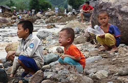
| After a flood that hit Hua Nam Hamlet, Nam Pam Commune, Muong La District in northern Son La Province in August, 2017.-VNA/VNS Photo Nguyen Cuong |
Decision No 705, signed on June 7 by Deputy Prime Minister Trinh Dinh Dung, approved the natural disaster forecasting programme to assess, map and update regions with high risks of catastrophes, especially those occurring on a regular basis, namely typhoons, floods, salinisation, droughts and so forth.
With an aim to prevent and overcome natural disasters, the programme focuses on vulnerable areas in lands, seas and islands. It evaluates the risk of calamities by region, establishing a warning map for tropical depressions, storms and rises in the sea level. The programme will determine floods, land subsidence and landslides in midlands and mountainous regions in addition to hail storms, heat waves, tornados, droughts, lightning, severe cold, rimes, earthquakes and tsunamis.
Dung urged the Ministry of Natural Resources and Environment and the Ministry of Agriculture and Rural Development (MARD) to look into the programme’s operations and results.
Natural disasters have been on the rise in Vietnam for the past 10 years, reported dantri.vn. According to MARD, 2017 was considered the peak of natural disasters, causing 385 deaths and a significant loss of VND60 trillion ($2.65 billion). There were 654 cases of injuries recorded, besides many missing people.
What the stars mean:
★ Poor ★ ★ Promising ★★★ Good ★★★★ Very good ★★★★★ Exceptional
Related Contents
Latest News
More News
- 14th National Party Congress wraps up with success (January 25, 2026 | 09:49)
- Congratulations from VFF Central Committee's int’l partners to 14th National Party Congress (January 25, 2026 | 09:46)
- List of newly-elected members of 14th Political Bureau announced (January 23, 2026 | 16:27)
- 14th Party Central Committee unanimously elects To Lam as General Secretary (January 23, 2026 | 16:22)
- List of members of 14th Party Central Committee announced (January 23, 2026 | 09:12)
- Highlights of fourth working day of 14th National Party Congress (January 23, 2026 | 09:06)
- Press provides timely, accurate coverage of 14th National Party Congress (January 22, 2026 | 09:49)
- Press release on second working day of 14th National Party Congress (January 22, 2026 | 09:19)
- Minister sets out key directions to promote intrinsic strength of Vietnamese culture (January 22, 2026 | 09:16)
- 14th National Party Congress: Renewed momentum for OVs to contribute to homeland (January 21, 2026 | 09:49)

 Tag:
Tag:


 Mobile Version