

Many islets disappearing in southern Vietnam
 |
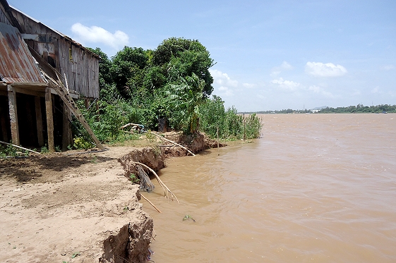
| Landsilde along the Hau River. |
Having lived for 48 years on Son Isle in the Hau River, a branch of the Mekong River, in Can Tho City, Cao Van Ba, 66 has witnessed the narrowing of the once prosperous land. His family is living in fear.
"In the past this isle was more than 100 hectares but now it is 60 hectares only. I have nearly 700sq.m of garden but due to landslides, the area is only half by now, after 10 years," Ba said.
Many households on this isle lost their land and had to leave. There are only 78 families with more than 300 people on the isle.
Pham Van Nhu is one of them. Nhu said he left the isle to live on the mainland because of fear of landslides.
Nhu previously owned 1 hectare of land on the islet. From 1978 to 2012 his family had to move their house 10 times owing to landslides and they lost 8,000sq.m of land. “I had to sell my remaining land at cheap price and move my family to the mainland," said Nhu.
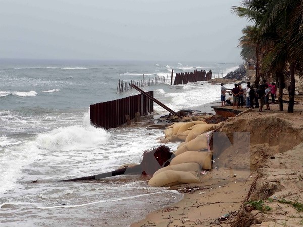
Overexploitation of sand from the river is the main cause for the serious landslide son Son islet.
At the same time, an isle named Ca Doi in the Hau River has disappeared.
In 1960, Ca Doi isle covered 20 hectares, with a length of 4km. The isle was reinforced annually by silt from upstream Mekong River. As it was very fertile, many residents in Tan Loc and Lap Vo districts of Dong Thap province planted sugarcane and rice.
The isle was named after the man who first went to the isle to plant crops – Mr. Ca Doi.
In 1990, the area of Ca Doi isletwas only 6 hectares and in 2015 it disappeared.
One million people affected
 |
After the disappearance of Ca Doi Isle, the local authorities and residents have been worried about landslides.
Also in Tan Loc district of Dong Thap province, within 6 years (2010-2016) Tan Loc isle lost nearly 10 hectares due to landslides, said Le Thanh Nghi, Deputy Chairman of Tan Loc ward.
Recently, about 50 people on Tan Loc isle chased after some sand exploiting boats to drive them far from their isle. The two sides had a fight, so the police had to investigate the case.
In An Giang and Dong Thap provinces, landslides are also a big problem, particularly on the isles of Long Phu Thuan, Tay, and Cho Moi.
A serious landslide occurred in mid-2011, which destroyed 250 houses along the Tien River.
The dangerous area spanned nearly 4 km long. The local government had to move all households in this area to a new resettlement zone.
Dong Thap province has more than 2,100 households in the landslide belt. The local government has asked for nearly VND900 billion ($42 million) from the central budget to deal with landslides.
Meanwhile, thousands of households in An Giang province living in dangerous areas of landslides have not been moved to a safe place.
The Ministry of Construction has asked the Prime Minister to approve a project to give shelter to about 44,800 households who are living in dangerous areas.
According to the Ministry of Agriculture and Rural Development, in recent years the southern region lost up to 500 hectares of land annually due to landslides.
Currently there are 265 points of landslides and erosion in the region, with a total length of 450 km. In addition, 200 km of coastline are in the same situation.
It is forecast that by 2050, about one million people in the region will be directly affected by coastal erosion and landslides.
Experts have identified one of the main causes leading to changes in water availability, land degradation and depletion of biodiversity in the Mekong Delta – the construction of hydropower dams in the upper Mekong River.
What the stars mean:
★ Poor ★ ★ Promising ★★★ Good ★★★★ Very good ★★★★★ Exceptional
Latest News


More News
- SLP Vietnam inaugurates rural road solar lighting project in Long An (April 19, 2024 | 07:12)
- Vietnam needs 20-30 billion USD investment for universal clean water access (April 16, 2024 | 17:10)
- Vietnam Airlines adjusts flight paths via Middle East (April 16, 2024 | 17:05)
- Vietnamese community in India stays united, contributes to homeland (April 15, 2024 | 11:42)
- Dien Bien Phu Victory celebrated in France (April 15, 2024 | 11:37)
- Vietnamese Embassy in Israel issues warning amid escalating tension (April 15, 2024 | 08:00)
- ADB forecasts 6 per cent growth for Vietnam (April 12, 2024 | 17:17)
- SCB, Van Thinh Phat execs convicted of embezzlement; Truong My Lan sentenced to death (April 12, 2024 | 09:59)
- Finnish kindergarten opens in Hanoi (April 12, 2024 | 09:50)
- Over 746 tonnes of rice allocated to Dien Bien, Bac Kan provinces in between-crop period (April 12, 2024 | 08:54)


 Mobile Version